Scenario window: March 13, 2026 00:00 UTC to March 17, 2026 00:00 UTC.
Scenario type: Hypothetical case study. This page is not a reconstruction of a confirmed spill event; it shows how a 96-hour leak near the Strait of Hormuz could evolve under modeled metocean conditions.
This page documents a hypothetical Aldadrift oil spill scenario near the eastern exit of the Strait of Hormuz. The goal is to make the modeling output easy to understand: where the spill spreads, when shoreline risk begins, and what a response team would want to know during the first 96 hours.
The scenario assumes a damaged tanker anchors offshore and leaks medium crude continuously for four days. Aldadrift runs the case in OpenOil using wind, currents, waves, and oil weathering processes to estimate how the slick evolves over time.
Why the Strait of Hormuz matters for spill planning
The Strait of Hormuz is one of the world's most important maritime chokepoints. Heavy tanker traffic, constrained routing, nearby coastlines, and sensitive marine habitats make it a high-consequence area for any oil spill scenario.
For planners, insurers, operators, and responders, the relevant question is not just whether an incident could happen. It is how quickly a release could threaten shipping lanes, coastal waters, and shoreline assets if a damaged vessel remains in place and continues leaking.
Scenario assumptions
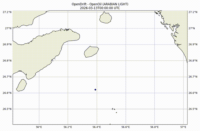
- Location: Northern Gulf of Oman, near shipping lanes exiting the Strait of Hormuz
- Scenario period: March 13, 2026 to March 17, 2026
- Release duration: 96 hours
- Model: Aldadrift OpenOil
- Forcing: Wind, ocean currents, waves, and oil weathering processes
- Simulation style: Probabilistic particle tracking
What the model is trying to answer
The core operational questions are straightforward:
- How quickly does the slick spread offshore?
- When does shoreline threat begin to emerge?
- Which coastline segments appear most exposed during the forecast window?
- How much uncertainty remains in the first two to four days?
These are the questions drift forecasting is built to answer during time-critical spill response.
Step-by-step timeline for March 13-17, 2026
The sections below translate the 96-hour scenario into a practical sequence that operations teams can read quickly.
March 13, 2026 00:00 UTC — release begins
A tanker carrying medium crude is assumed to be damaged and anchored offshore. Oil begins leaking from a compromised tank, creating a concentrated slick around the vessel.
At this early stage, the spill remains relatively compact. The first operational task would be to establish whether the source can be stabilized before the footprint widens.
March 13, 2026 12:00 UTC — the slick broadens
Within the first 12 hours, wind and surface currents begin pushing oil away from the source. The slick expands laterally, shipping lanes near the vessel start to face contamination risk, and response planning becomes more complicated.
If containment assets are available, this is the period when response teams still have the best chance to limit offshore spread.
March 14, 2026 00:00 UTC — the plume fragments
After roughly 24 hours, the model shows a much larger footprint and a more fragmented plume. Multiple patches begin moving under slightly different forcing, which makes visual tracking and containment harder.
This is the point where the incident shifts from a localized vessel problem to a wider regional spill management problem.
March 15, 2026 00:00 UTC — shoreline threat window emerges
By around 48 hours, the model indicates that nearshore waters begin to enter the threat envelope. First shoreline contact becomes plausible shortly after this point, depending on exact conditions and how the plume fragments continue to evolve.
From a response perspective, this is when coastline prioritization matters most. Sensitive sites such as fisheries, beaches, rocky shoreline, and desalination infrastructure become higher-priority planning targets.
March 16, 2026 00:00 UTC — contamination begins to organize along shore
By roughly 72 hours, the scenario points to more organized shoreline exposure. Small stranding clusters begin appearing along the coast, and cleanup complexity increases materially because oil is no longer only an offshore containment problem.
At this stage, even a modest fraction of the total release can create outsized consequences for shoreline operations, habitat protection, and cleanup logistics.
March 17, 2026 00:00 UTC — full 96-hour impact picture
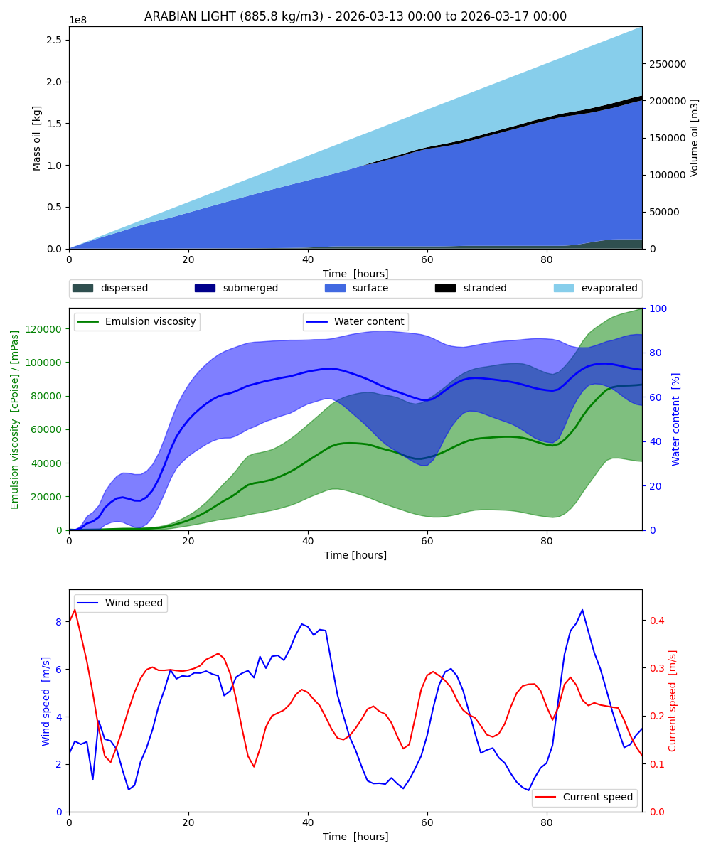
At the end of the scenario window, the spill footprint covers a broad offshore area and several shoreline segments show contamination risk. The model output suggests that approximately 29.59 km of coastline may be impacted in this case study.
Even where shoreline oiling remains thin, the operational burden can still be substantial because response must continue across multiple locations while the remaining offshore oil keeps drifting.
Stranding events
Stranding events are grouped by clustering first-stranding positions and times. Two particles belong to the same event if they fall within 1 km spatially and 6 hours temporally. Impacted coast length is measured as the shoreline length intersecting a 500 m buffer around each event cluster.
| Event | Oil mass (kg) | Start | Duration (h) | Centre (lat°, lon°) | Coast (km) | Loading (m³/km) |
|---|---|---|---|---|---|---|
| 1 | 2,028,839.09 | +50.0h | 3.0 | 26.83889°, 56.38162° | 9.434 | 242.7771 |
| 2 | 3,316,185.28 | +60.0h | 31.0 | 26.82780°, 56.33379° | 11.354 | 329.7031 |
| 3 | 242,041.64 | +75.0h | 3.0 | 26.86300°, 56.40969° | 4.013 | 68.0882 |
| 4 | 262,765.70 | +89.0h | 3.0 | 26.83826°, 56.38460° | 4.793 | 61.8916 |
Total coastline impacted: 29.59 km.
Aldadrift scenario outputs
OpenOil forecast assets for the March 13-17, 2026 hypothetical scenario.
Operational takeaways
This case study is hypothetical, but the planning value is real. A response team looking at this output would likely focus on:
- source control and offshore containment in the first 12 to 24 hours
- coastline prioritization before the 48 to 72 hour window
- shoreline access, cleanup sequencing, and environmental protection once stranding clusters begin to appear
- uncertainty management as the plume fragments into multiple evolving patches
Why this type of scenario page matters
A strong drift forecast is not just a map. It is a decision-support tool that helps teams estimate timing, exposure, and response priorities before the spill reaches shore.
If you want to understand how Aldadrift handles programmatic forecasting, see the drift forecasting API page. If you are evaluating commercial use, review pricing or run your own forecast in the app.
Frequently asked questions
Is this page describing a real spill?
No. This page describes a hypothetical scenario run for March 13, 2026 through March 17, 2026 to illustrate how a spill near the Strait of Hormuz could evolve over 96 hours.
What dates does the scenario cover?
The modeled release begins on March 13, 2026 at 00:00 UTC and the scenario ends on March 17, 2026 at 00:00 UTC.
What does the model show?
The scenario shows offshore spread, shoreline threat, stranding events, impacted coastline estimates, and visual outputs including a report and animation.